Fichier:Orkney Islands UK relief location map.jpg
Taille de cet aperçu : 467 × 599 pixels. Autres résolutions : 187 × 240 pixels | 374 × 480 pixels | 598 × 768 pixels | 798 × 1 024 pixels | 2 004 × 2 572 pixels.
Fichier d’origine (2 004 × 2 572 pixels, taille du fichier : 357 kio, type MIME : image/jpeg)
Ce fichier et sa description proviennent de Wikimedia Commons.
| Description |
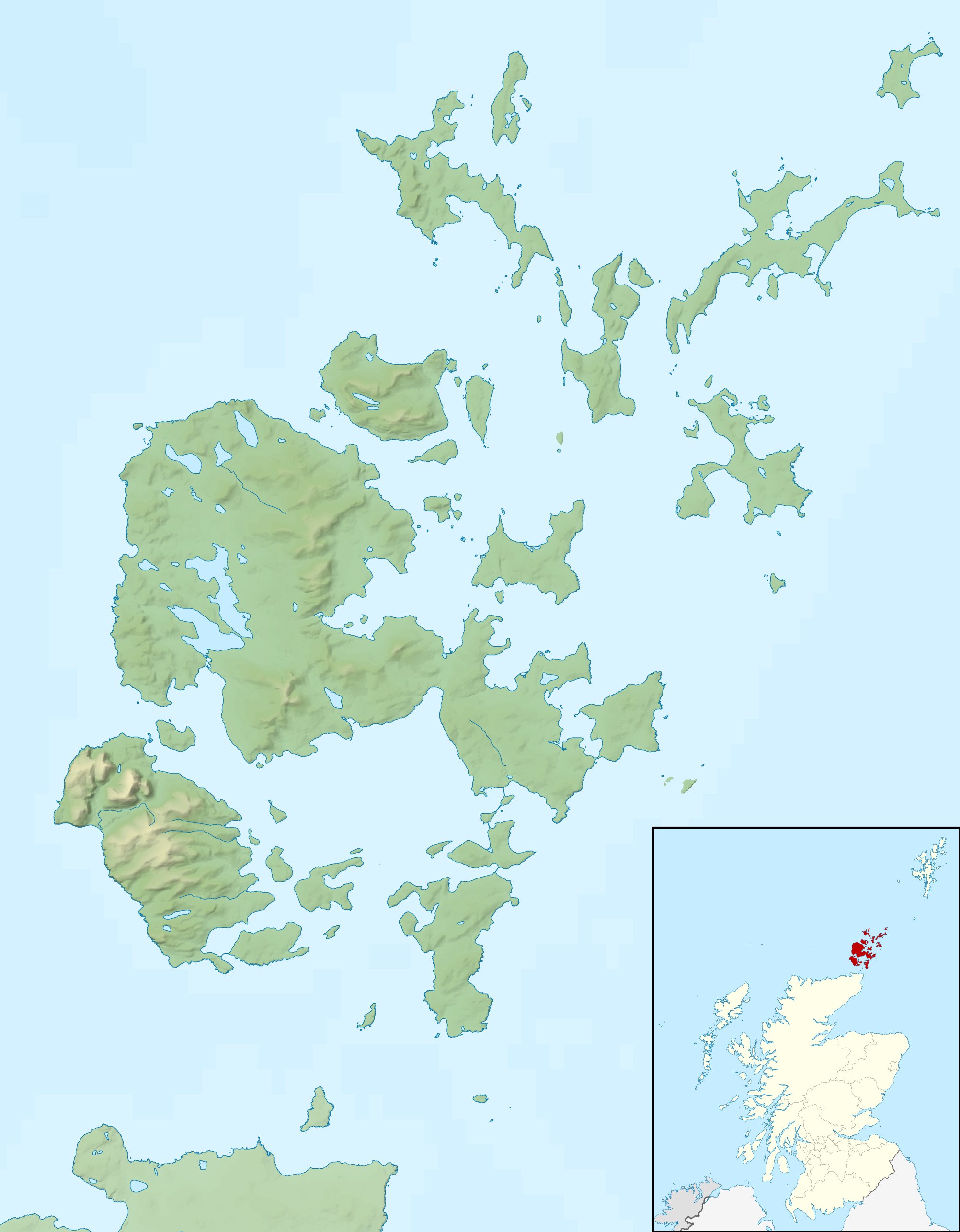
Relief map of the Orkney Islands (excluding Sule Stack and Sule Skerry), UK. Equirectangular map projection on WGS 84 datum, with N/S stretched 180% Geographic limits:
|
| Date | |
| Source |
|
| Auteur | Nilfanion, created using Ordnance Survey data |
| Autorisation (Réutilisation de ce fichier) |
Ce fichier est disponible selon les termes de la licence Creative Commons Attribution – Partage dans les Mêmes Conditions 3.0 (non transposée). Attribution: Contains Ordnance Survey data © Crown copyright and database right
|
| Autres versions | File:Orkney Islands UK blank map.svg - Blank map |
Historique du fichier
Cliquer sur une date et heure pour voir le fichier tel qu'il était à ce moment-là.
| Date et heure | Vignette | Dimensions | Utilisateur | Commentaire | |
|---|---|---|---|---|---|
| actuel | 30 novembre 2011 à 14:26 | | 2 004 × 2 572 (357 kio) | Nilfanion | {{Information |Description=Relief map of the Orkney Islands (excluding Sule Stack and Sule Skerry), UK. Equirectangular map projection on WGS 84 datum, with N/S stretched 180% Geographic limits: *W |
Utilisation du fichier
Les 62 pages suivantes utilisent ce fichier :
- Auskerry
- Barnhouse
- Black Holm
- Brough of Birsay
- Burray
- Cairn dolménique de Midhowe
- Calf of Eday
- Calf of Flotta
- Cava (Écosse)
- Clettack Skerry
- Copinsay
- Corn Holm
- Damsay
- Eday
- Egilsay
- Eynhallow
- Fara (Écosse)
- Faray
- Flotta
- Gairsay
- Glimps Holm
- Graemsay
- Helliar Holm
- Holm of Faray
- Holm of Huip
- Holm of Papay
- Holm of Scockness
- Hoy (Orcades)
- Hunda
- Lamb Holm
- Linga Holm
- Little Skerry
- Loch de Stenness
- Louther Skerry
- Mainland (Orcades)
- Muckle Green Holm
- Muckle Skerry
- North Ronaldsay
- Old Man of Hoy
- Orcades
- Papa Stronsay
- Papa Westray
- Pentland Firth
- Pentland Skerries
- Rousay
- Rusk Holm
- Rysa Little
- Sabordage de la flotte allemande à Scapa Flow
- Sanday (Orcades)
- Scapa Flow
- Shapinsay
- South Ronaldsay
- South Walls
- Stronsay
- Sweyn Holm
- Switha
- Swona
- Thieves Holm
- Ward Hill
- Westray (Écosse)
- Wyre (Écosse)
- Modèle:Géolocalisation/Orcades
Usage global du fichier
Les autres wikis suivants utilisent ce fichier :
- Utilisation sur ar.wiki.x.io
- Utilisation sur bg.wiki.x.io
- Utilisation sur ceb.wiki.x.io
- Utilisation sur de.wiki.x.io
- Scapa Flow
- Bootsgrab von Scar
- Inganess Bay
- Westray Stone
- Taversoe Tuick
- Yetnasteen
- Sule Stack
- Blackhammer
- Broch von Windwick
- Knowes o’ Trotty
- Damsay
- Wideford Hill Cairn
- Vorlage:Positionskarte Schottland Orkney
- Benutzer:Metilsteiner/KARTENDIENSTE
- Loch of Stenness
- Loch of Harray
- Souterrain von Windwick
- Ness of Brodgar
- Benutzer Diskussion:Thgoiter/Archiv/2013
- Gräberfeld von Westness
- Benutzer Diskussion:Metilsteiner/Archiv/2013/April
- Muckle Skerry (Orkney)
- Kili Holm
- Kirkwall Castle
- Menhire von Stanerandy
- Holm of Grimbister
- Utilisation sur el.wiki.x.io
- Utilisation sur en.wiki.x.io
Voir davantage sur l’utilisation globale de ce fichier.