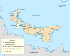
Fichier:Acadie Ile-du-Prince-Édouard fr.svg

Taille de cet aperçu PNG pour ce fichier SVG : 758 × 600 pixels. Autres résolutions : 303 × 240 pixels | 607 × 480 pixels | 971 × 768 pixels | 1 280 × 1 013 pixels | 2 560 × 2 025 pixels | 1 039 × 822 pixels.
Fichier d’origine (Fichier SVG, nominalement de 1 039 × 822 pixels, taille : 453 kio)
Historique du fichier
Cliquer sur une date et heure pour voir le fichier tel qu'il était à ce moment-là.
| Date et heure | Vignette | Dimensions | Utilisateur | Commentaire | |
|---|---|---|---|---|---|
| actuel | 22 septembre 2023 à 10:05 |  | 1 039 × 822 (453 kio) | Lalpino | File uploaded using svgtranslate tool (https://svgtranslate.toolforge.org/). Added translation for ca. |
| 17 avril 2011 à 17:27 |  | 1 039 × 822 (439 kio) | Dr Wilson | Retouches | |
| 3 avril 2011 à 06:08 |  | 1 039 × 822 (531 kio) | Dr Wilson | {{Information |Description={{en|Map of acadian communities in Prince Edward Island, Canada}} Equirectangular projection, N/S stretching 145 %. Geographic limits of the map: * N: 47.3° N * S: 45 |
Utilisation du fichier
Les 3 pages suivantes utilisent ce fichier :


