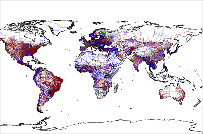
Fichier:World administrative levels.png

Taille de cet aperçu : 800 × 527 pixels. Autres résolutions : 320 × 211 pixels | 640 × 421 pixels | 1 024 × 674 pixels | 1 280 × 843 pixels | 1 602 × 1 055 pixels.
Fichier d’origine (1 602 × 1 055 pixels, taille du fichier : 88 kio, type MIME : image/png)
Historique du fichier
Cliquer sur une date et heure pour voir le fichier tel qu'il était à ce moment-là.
| Date et heure | Vignette | Dimensions | Utilisateur | Commentaire | |
|---|---|---|---|---|---|
| actuel | 17 septembre 2022 à 05:46 |  | 1 602 × 1 055 (88 kio) | Durranistan | . |
| 17 septembre 2022 à 05:20 |  | 1 602 × 1 055 (87 kio) | Durranistan | removed FATA | |
| 18 avril 2020 à 03:12 |  | 1 601 × 1 054 (111 kio) | IAmBrazilian | Update France + Brazil | |
| 6 septembre 2018 à 22:54 |  | 1 601 × 1 054 (111 kio) | Janitoalevic | Updated Chilean Regions | |
| 18 septembre 2013 à 01:15 |  | 1 601 × 1 054 (183 kio) | Spesh531 | updated sudans, and greenland | |
| 19 février 2013 à 20:09 |  | 1 601 × 1 054 (226 kio) | Аришин Дмитрий | -6 Russian subjects | |
| 1 août 2007 à 15:09 |  | 1 601 × 1 054 (155 kio) | Rarelibra | Updated 8/01/07 - North and South Korea updated (lvl 2), Japan updated (lvls 2,3,4), Hungary updated (lvl 2)... | |
| 29 mars 2007 à 22:00 |  | 1 281 × 878 (109 kio) | Rarelibra | Updated 3/20/07 | |
| 18 janvier 2007 à 22:52 |  | 1 281 × 878 (113 kio) | Rarelibra | Map of the world administrative levels from the database that I am continually assembling/updating. The color schema is: BLACK - level 0 (249 countries) BLUE - level 1 (233 countries) BROWN - level 2 (139 countries) GRAY - level 3 (34 countries) GREEN - l |
Utilisation du fichier
Les 2 pages suivantes utilisent ce fichier :
Usage global du fichier
Les autres wikis suivants utilisent ce fichier :
- Utilisation sur ar.wiki.x.io
- Utilisation sur arz.wiki.x.io
- Utilisation sur ast.wiki.x.io
- Utilisation sur as.wiki.x.io
- Utilisation sur av.wiki.x.io
- Utilisation sur az.wiki.x.io
- Utilisation sur ban.wiki.x.io
- Utilisation sur ba.wiki.x.io
- Utilisation sur be-tarask.wiki.x.io
- Utilisation sur be.wiki.x.io
- Utilisation sur bn.wiki.x.io
- Utilisation sur br.wiki.x.io
- Utilisation sur bs.wiki.x.io
- Utilisation sur ca.wiki.x.io
- Utilisation sur ce.wiki.x.io
- Utilisation sur da.wiki.x.io
- Utilisation sur de.wiki.x.io
- Utilisation sur en.wiki.x.io
- List of administrative divisions by country
- Wikipedia:WikiProject Organizations/Location
- User talk:Electionworld/Archive 4
- User:Wavelength/About geography
- File talk:H1N1 map.svg/Archive 3
- Talk:2009 swine flu pandemic/Archive 7
- Wikipedia:Graphics Lab/Map workshop/Archive/May 2011
- User:PK2/List of administrative divisions by country
- Utilisation sur es.wiki.x.io
- Utilisation sur eu.wiki.x.io
- Utilisation sur fa.wiki.x.io
- Utilisation sur gl.wiki.x.io
- Utilisation sur hak.wiki.x.io
- Utilisation sur hi.wiki.x.io
- Utilisation sur hr.wiki.x.io
- Utilisation sur ia.wiki.x.io
- Utilisation sur id.wiki.x.io
- Utilisation sur incubator.wikimedia.org
- Utilisation sur it.wiki.x.io
- Utilisation sur ja.wiki.x.io
Voir davantage sur l’utilisation globale de ce fichier.


