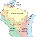
Fichier:Wisconsin geographic provinces.svg

Taille de cet aperçu PNG pour ce fichier SVG : 585 × 600 pixels. Autres résolutions : 234 × 240 pixels | 468 × 480 pixels | 749 × 768 pixels | 998 × 1 024 pixels | 1 997 × 2 048 pixels | 1 015 × 1 041 pixels.
Fichier d’origine (Fichier SVG, nominalement de 1 015 × 1 041 pixels, taille : 213 kio)
Historique du fichier
Cliquer sur une date et heure pour voir le fichier tel qu'il était à ce moment-là.
| Date et heure | Vignette | Dimensions | Utilisateur | Commentaire | |
|---|---|---|---|---|---|
| actuel | 16 mars 2010 à 15:24 |  | 1 015 × 1 041 (213 kio) | Jua Cha | increased border width |
| 16 mars 2010 à 05:33 |  | 1 015 × 1 041 (213 kio) | Jua Cha | {{Information |Description={{en|1=Map of the geographic regions of Wisconsin.}} |Source=Own work based on the following sources: *Base map for state and county boundaries: File:Map of Wisconsin highlighting Adams County.svg by [[User:Dbenbenn|Da |
Utilisation du fichier
Les 2 pages suivantes utilisent ce fichier :
Usage global du fichier
Les autres wikis suivants utilisent ce fichier :
- Utilisation sur ar.wiki.x.io
- Utilisation sur arz.wiki.x.io
- Utilisation sur de.wiki.x.io
- Utilisation sur en.wiki.x.io
- Utilisation sur et.wiki.x.io
- Utilisation sur eu.wiki.x.io
- Utilisation sur fy.wiki.x.io
- Utilisation sur hu.wiki.x.io
- Utilisation sur ja.wiki.x.io
- Utilisation sur ro.wiki.x.io
- Utilisation sur te.wiki.x.io