Fichier:Vettones cities location map-fr.svg

Taille de cet aperçu PNG pour ce fichier SVG : 600 × 600 pixels. Autres résolutions : 240 × 240 pixels | 480 × 480 pixels | 768 × 768 pixels | 1 024 × 1 024 pixels | 2 048 × 2 048 pixels | 1 900 × 1 900 pixels.
Fichier d’origine (Fichier SVG, nominalement de 1 900 × 1 900 pixels, taille : 1,96 Mio)
Ce fichier et sa description proviennent de Wikimedia Commons.
Description
| Description |
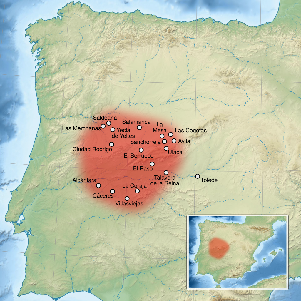
English: Map of Vettones main cities and territory, in the Iberian Peninsula. Limits of the map : N 44, W -10, S 35.5, E 4.5. Projection UTM. Français : Carte du territoire et des principales cités du peuple des Vettons, dans la péninsule Ibérique. Limites de la carte : N 44, O -10, S 35.5, E 4.5. Projection UTM. |
||
| Date | (UTC) | ||
| Source |
Travail personnel. English: Source :
Français : Source :
|
||
| Auteur | Sémhur (talk) | ||
| Autres versions |
File:Vettones location map-blank.svg : Blank map, without relief and cities. | ||
| Attribution (imposé par la licence) | © Sémhur / Wikimedia Commons / | ||
| SVG | W3C-validity not checked. Cette image vectorielle SVG non W3C-spécifiée a été créée avec Inkscape .
|
||
| Graphic Lab |

| Lieu de la prise de vue | | Voir cet endroit et d’autres images sur : OpenStreetMap |
|---|
Conditions d’utilisation
Moi, en tant que détenteur des droits d’auteur sur cette œuvre, je la publie sous les licences suivantes :
| Copyleft : cette œuvre d’art est libre ; vous pouvez la redistribuer ou la modifier selon les termes de la licence Art Libre. Vous trouverez un exemplaire de cette licence sur le site Copyleft Attitude ainsi que sur d’autres sites. |
Ce fichier est sous licence Creative Commons Attribution - Partage Dans Les Mêmes Conditions 4.0 International, 3.0 Non Transposé, 2.5 Générique, 2.0 Générique et 1.0 Générique.
- Vous êtes libre :
- de partager – de copier, distribuer et transmettre cette œuvre
- d’adapter – de modifier cette œuvre
- Sous les conditions suivantes :
- paternité – Vous devez donner les informations appropriées concernant l'auteur, fournir un lien vers la licence et indiquer si des modifications ont été faites. Vous pouvez faire cela par tout moyen raisonnable, mais en aucune façon suggérant que l’auteur vous soutient ou approuve l’utilisation que vous en faites.
- partage à l’identique – Si vous modifiez, transformez ou vous basez sur cet élément, vous devez distribuer votre contribution sous une license identique ou compatible à celle de l’original.
Vous pouvez choisir l’une de ces licences.
Historique du fichier
Cliquer sur une date et heure pour voir le fichier tel qu'il était à ce moment-là.
| Date et heure | Vignette | Dimensions | Utilisateur | Commentaire | |
|---|---|---|---|---|---|
| actuel | 4 avril 2013 à 14:01 | | 1 900 × 1 900 (1,96 Mio) | Sémhur | Correcting SVG errors. |
| 3 avril 2013 à 14:07 |  | 1 900 × 1 900 (1,96 Mio) | Sémhur | correct the position of Talavera de la Reina Ucala => Ulaca | |
| 10 mars 2013 à 21:47 |  | 1 900 × 1 900 (1,96 Mio) | Asqueladd | Correction of position mainly of Talavera de la Reina, which is located roughly in the concave bend of the Tajo River, not the convex one in the west. Check google maps for more info in the subject. | |
| 18 mars 2012 à 19:26 |  | 1 900 × 1 900 (1,95 Mio) | Sémhur | with the good dimensions | |
| 18 mars 2012 à 19:09 |  | 512 × 512 (1,95 Mio) | Sémhur | == {{int:filedesc}} == {{Information |Description={{Multilingual description |en= Map of Vettones main cities and territory, in the Iberian Peninsula. |fr= Carte du territoire et des principales cités du peuple des fr:Vettons, d... |
Utilisation du fichier
Les 2 pages suivantes utilisent ce fichier :
Usage global du fichier
Les autres wikis suivants utilisent ce fichier :
- Utilisation sur gl.wiki.x.io