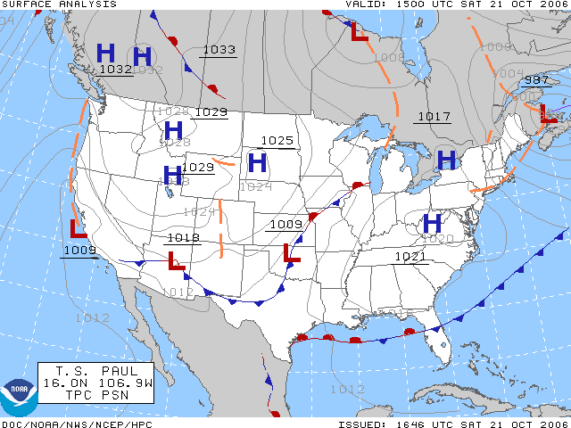
Fichier:Surface analysis.gif
Surface_analysis.gif (640 × 480 pixels, taille du fichier : 26 kio, type MIME : image/gif)
Historique du fichier
Cliquer sur une date et heure pour voir le fichier tel qu'il était à ce moment-là.
| Date et heure | Vignette | Dimensions | Utilisateur | Commentaire | |
|---|---|---|---|---|---|
| actuel | 29 janvier 2007 à 00:51 |  | 640 × 480 (26 kio) | BenFrantzDale~commonswiki | Same picture, changed red and blue to be less vivid. |
| 21 octobre 2006 à 19:33 |  | 640 × 480 (26 kio) | Runningonbrains | The surface analysis for the United States on October 21, 2006. Plotted by the HPC. ==Licencing== {{PD-USGov-NOAA}} |
Utilisation du fichier
Les 3 pages suivantes utilisent ce fichier :
Usage global du fichier
Les autres wikis suivants utilisent ce fichier :
- Utilisation sur ar.wiki.x.io
- Utilisation sur azb.wiki.x.io
- Utilisation sur az.wiki.x.io
- Utilisation sur ca.wiki.x.io
- Utilisation sur chr.wiki.x.io
- Utilisation sur ckb.wiki.x.io
- Utilisation sur cs.wiki.x.io
- Utilisation sur de.wiki.x.io
- Utilisation sur el.wiki.x.io
- Utilisation sur en.wiki.x.io
- Meteorology
- Surface weather analysis
- Anticyclone
- Weather map
- High-pressure area
- Synoptic scale meteorology
- Warm front
- Weather Prediction Center
- Pressure system
- Portal:Maps/Selected article
- Wikipedia:Today's featured article/November 2007
- Web mapping
- Wikipedia:Today's featured article/November 24, 2007
- History of surface weather analysis
- Portal:Weather/Selected article/4
- Portal:Maps/Selected article/10
- File talk:Surface analysis.gif
- Portal:Weather/Selected article
- Utilisation sur en.wikibooks.org
- Utilisation sur es.wiki.x.io
- Utilisation sur et.wiki.x.io
- Utilisation sur fa.wiki.x.io
- Utilisation sur fo.wiki.x.io
- Utilisation sur hr.wiki.x.io
- Utilisation sur id.wiki.x.io
- Utilisation sur ja.wiki.x.io
Voir davantage sur l’utilisation globale de ce fichier.

