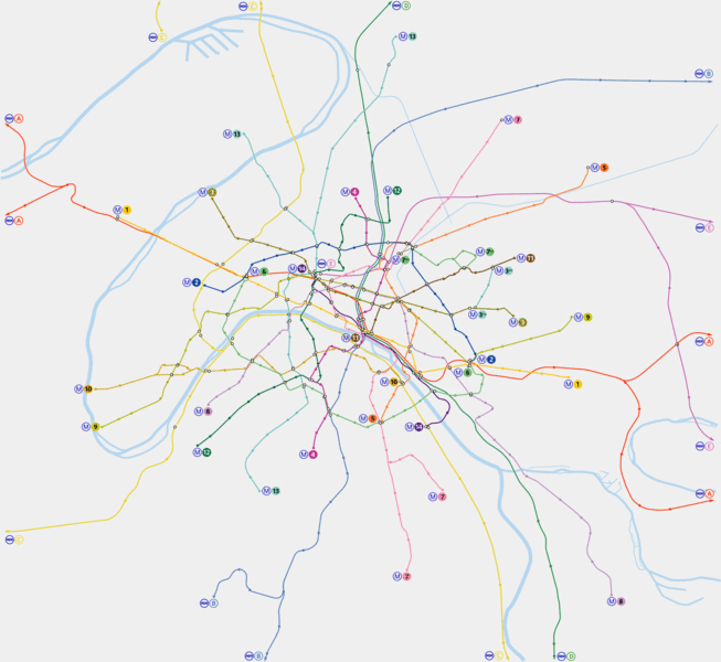
Fichier:Paris Metro map.gif

Taille de cet aperçu : 653 × 600 pixels. Autres résolutions : 261 × 240 pixels | 523 × 480 pixels | 836 × 768 pixels | 1 115 × 1 024 pixels | 1 927 × 1 770 pixels.
Fichier d’origine (1 927 × 1 770 pixels, taille du fichier : 214 kio, type MIME : image/gif)
Ce fichier et sa description proviennent de Wikimedia Commons.

|
This map is outdated and not maintained. Please use the vector version. |
Description
Author: en:Metropolitan
Origin: en:Image:Paris Metro map.gif
Description: Paris metro network pictured at a geographically accurate scale. Released by the author into the public domain.
Conditions d’utilisation

|
Une version vectorielle de cette image existe, dans le format « SVG ». Elle devrait être utilisée à la place de cette image matricielle.
File:Paris Metro map.gif → File:Paris Metro map.svg
Pour plus d’informations sur les images vectorielles, consultez la page de transition de Commons vers le format SVG. Voir aussi les informations à propos de la manière dont le logiciel MediaWiki gère les images au format SVG. |
 |
| |
Cette image a été (ou est ici-même) mise à disposition dans le domaine public par son auteur, Metropolitan dans le projet anglais Wikimedia Commons. Ceci s'applique partout dans le monde. Au cas où cela n'est pas possible légalement : |
Historique du fichier
Cliquer sur une date et heure pour voir le fichier tel qu'il était à ce moment-là.
| Date et heure | Vignette | Dimensions | Utilisateur | Commentaire | |
|---|---|---|---|---|---|
| actuel | 2 mai 2006 à 06:12 | | 1 927 × 1 770 (214 kio) | Gonioul | |
| 14 décembre 2005 à 16:12 |  | 1 899 × 1 769 (175 kio) | Poulpy | == Summary == '''Author''': en:Metropolitan '''Origin''': en:Image:Paris Metro map.gif '''Description''': Paris metro network pictured at a geographically accurate scale. Released by the author into the public domain. |
Utilisation du fichier
Aucune page n’utilise ce fichier.
Usage global du fichier
Les autres wikis suivants utilisent ce fichier :
- Utilisation sur ca.wiki.x.io
- Utilisation sur cv.wiki.x.io
- Utilisation sur en.wiki.x.io
- Utilisation sur eo.wiki.x.io
- Utilisation sur es.wiki.x.io
- Utilisation sur ja.wiki.x.io
- Utilisation sur lb.wiki.x.io
- Utilisation sur sk.wiki.x.io