Fichier:Pacific hurricane tracks 1980-2005.jpg

Fichier d’origine (5 200 × 3 200 pixels, taille du fichier : 2,26 Mio, type MIME : image/jpeg)
Ce fichier et sa description proviennent de Wikimedia Commons.
Description
| Saffir-Simpson Hurricane Scale | ||||||
| TD | TS | 1 | 2 | 3 | 4 | 5 |
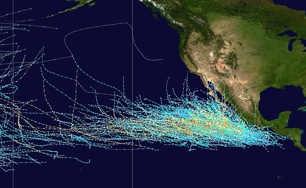
This map shows the tracks of all Tropical cyclones in the Northeast Pacific Ocean from 1980 to 2005. Both the International Date Line and 140° W longitude are marked on the map. The Date Line is the westernmost boundary of the basin and 140° W is the boundary between the Central and East Pacific. The points show the locations of the storms at six-hourly intervals and use the color scheme shown above from Saffir-Simpson Hurricane Scale.
Conditions d’utilisation
Created using User:jdorje/Tracks by Nilfanion on 2007-02-19. Background image from Image:Whole world - land and oceans.jpg (NASA). The best track information is from the National Hurricane Center.[1] copie d'archive sur Wayback Machine
| Moi, propriétaire des droits d’auteur sur cette œuvre, la place dans le domaine public. Ceci s'applique dans le monde entier. Dans certains pays, ceci peut ne pas être possible ; dans ce cas : J’accorde à toute personne le droit d’utiliser cette œuvre dans n’importe quel but, sans aucune condition, sauf celles requises par la loi. |
Historique du fichier
Cliquer sur une date et heure pour voir le fichier tel qu'il était à ce moment-là.
| Date et heure | Vignette | Dimensions | Utilisateur | Commentaire | |
|---|---|---|---|---|---|
| actuel | 27 février 2007 à 23:20 | | 5 200 × 3 200 (2,26 Mio) | Nilfanion | {|Description={|align="{{{align|right}}}" border="0" cellspacing="0" cellpadding="0" style="background:transparent;text-align:center" |- |colspan="7" nowrap="nowrap"| <small>Saffir-Simpson Hurricane Scale</small> |- |s |
Utilisation du fichier
Les 2 pages suivantes utilisent ce fichier :
Usage global du fichier
Les autres wikis suivants utilisent ce fichier :
- Utilisation sur de.wiki.x.io
- Utilisation sur en.wiki.x.io
- Utilisation sur es.wiki.x.io
- Utilisation sur ms.wiki.x.io
- Utilisation sur pt.wiki.x.io
- Utilisation sur ru.wiki.x.io
- Utilisation sur th.wiki.x.io
- Utilisation sur uk.wiki.x.io
- Utilisation sur vi.wiki.x.io
- Utilisation sur zh.wiki.x.io