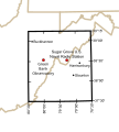
Fichier:National Radio Quiet Zone.svg

Taille de cet aperçu PNG pour ce fichier SVG : 541 × 600 pixels. Autres résolutions : 216 × 240 pixels | 433 × 480 pixels | 692 × 768 pixels | 923 × 1 024 pixels | 1 847 × 2 048 pixels | 679 × 753 pixels.
Fichier d’origine (Fichier SVG, nominalement de 679 × 753 pixels, taille : 121 kio)
Historique du fichier
Cliquer sur une date et heure pour voir le fichier tel qu'il était à ce moment-là.
| Date et heure | Vignette | Dimensions | Utilisateur | Commentaire | |
|---|---|---|---|---|---|
| actuel | 6 octobre 2020 à 04:00 |  | 679 × 753 (121 kio) | Arlo Barnes | four years belated update |
| 17 novembre 2009 à 05:26 |  | 679 × 753 (529 kio) | Denelson83 | Fix mis-labelling of 38°00'N as "38°30'" | |
| 28 octobre 2009 à 09:17 |  | 679 × 753 (524 kio) | Spellcheck | Converted text to outlines | |
| 28 octobre 2009 à 09:14 |  | 679 × 753 (355 kio) | Spellcheck | Increased font size for better thumbnail. | |
| 28 octobre 2009 à 08:36 |  | 679 × 753 (355 kio) | Spellcheck | {{Information |Description={{en|1=The location of the United States National Radio Quiet Zone and major locations within it.}} |Source=Derivative of public-domain http://en.wiki.x.io/wiki/File:Map_of_current_Interstates.svg Information from http://www |
Utilisation du fichier
La page suivante utilise ce fichier :
Usage global du fichier
Les autres wikis suivants utilisent ce fichier :
- Utilisation sur ar.wiki.x.io
- Utilisation sur de.wiki.x.io
- Utilisation sur en.wiki.x.io
- Utilisation sur fa.wiki.x.io
- Utilisation sur it.wiki.x.io
- Utilisation sur ja.wiki.x.io
- Utilisation sur pt.wiki.x.io
- Utilisation sur ru.wiki.x.io
- Utilisation sur uk.wiki.x.io
- Utilisation sur www.wikidata.org
- Utilisation sur zh.wiki.x.io