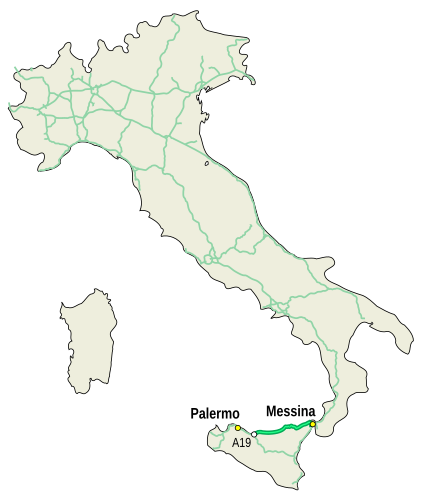
Fichier:Mappa autostrada A20 Italia.svg

Taille de cet aperçu PNG pour ce fichier SVG : 425 × 500 pixels. Autres résolutions : 204 × 240 pixels | 408 × 480 pixels | 653 × 768 pixels | 870 × 1 024 pixels | 1 741 × 2 048 pixels.
Fichier d’origine (Fichier SVG, nominalement de 425 × 500 pixels, taille : 52 kio)
Historique du fichier
Cliquer sur une date et heure pour voir le fichier tel qu'il était à ce moment-là.
| Date et heure | Vignette | Dimensions | Utilisateur | Commentaire | |
|---|---|---|---|---|---|
| actuel | 21 décembre 2009 à 22:05 |  | 425 × 500 (52 kio) | Gigillo83 | Aggiornamento rete autostradale |
| 16 novembre 2006 à 11:56 |  | 425 × 500 (36 kio) | ColdShine | ||
| 3 novembre 2006 à 20:27 |  | 425 × 500 (36 kio) | ColdShine | {{Information| |Description= {{en|Map of autostrada A20, Italy.}} {{es|Mapa de autostrada A20, Italia.}} {{it|Mappa dell'autostrada A20, Italia.}} |Source= {{en|Own work.}} {{es|Mi propio trabajo.}} {{it|Fatta da me.}} |Date=03/11/2006 |Author={{User:Cold |
Utilisation du fichier
La page suivante utilise ce fichier :
Usage global du fichier
Les autres wikis suivants utilisent ce fichier :
- Utilisation sur hu.wiki.x.io
- Utilisation sur lmo.wiki.x.io
- Utilisation sur nl.wiki.x.io
- Utilisation sur pl.wiki.x.io
- Utilisation sur pt.wiki.x.io
- Utilisation sur sh.wiki.x.io
- Utilisation sur sr.wiki.x.io
- Utilisation sur uk.wiki.x.io
- Utilisation sur www.wikidata.org
- Utilisation sur zh.wiki.x.io