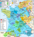
Fichier:Map France 1477-en sovereign Béarn.png

Taille de cet aperçu : 556 × 599 pixels. Autres résolutions : 223 × 240 pixels | 445 × 480 pixels | 900 × 970 pixels.
Fichier d’origine (900 × 970 pixels, taille du fichier : 608 kio, type MIME : image/png)
Historique du fichier
Cliquer sur une date et heure pour voir le fichier tel qu'il était à ce moment-là.
| Date et heure | Vignette | Dimensions | Utilisateur | Commentaire | |
|---|---|---|---|---|---|
| actuel | 7 avril 2024 à 19:20 |  | 900 × 970 (608 kio) | Jouvencel | First map was correct. Brittany was in the kingdom but not the royal domain. |
| 31 janvier 2019 à 23:49 |  | 900 × 970 (602 kio) | Iñaki LL | Brittany not in the Kingdom of France | |
| 9 juin 2014 à 21:27 |  | 900 × 970 (608 kio) | Iñaki LLM | User created page with UploadWizard |
Utilisation du fichier
Les 2 pages suivantes utilisent ce fichier :
Usage global du fichier
Les autres wikis suivants utilisent ce fichier :
- Utilisation sur azb.wiki.x.io
- Utilisation sur el.wiki.x.io
- Utilisation sur en.wiki.x.io
- Utilisation sur eu.wiki.x.io
- Utilisation sur he.wiki.x.io
- Utilisation sur it.wiki.x.io
- Utilisation sur uk.wiki.x.io