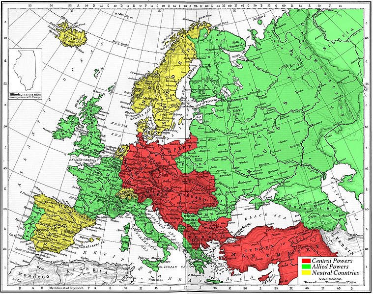
Fichier:Map 1914 WWI Alliances.jpg

Taille de cet aperçu : 759 × 599 pixels. Autres résolutions : 304 × 240 pixels | 608 × 480 pixels | 973 × 768 pixels | 1 280 × 1 011 pixels | 1 682 × 1 328 pixels.
Fichier d’origine (1 682 × 1 328 pixels, taille du fichier : 615 kio, type MIME : image/jpeg)
Historique du fichier
Cliquer sur une date et heure pour voir le fichier tel qu'il était à ce moment-là.
| Date et heure | Vignette | Dimensions | Utilisateur | Commentaire | |
|---|---|---|---|---|---|
| actuel | 6 novembre 2005 à 16:09 |  | 1 682 × 1 328 (615 kio) | Knutux | Map of Europe's alliances in 1915. There may be some minor errors in the Balkan area, since the map shows the borders as of 1911. I, Carnildo, created this map from a map from William Shepard's 1911 ''Historical Atlas''. The o |
Utilisation du fichier
La page suivante utilise ce fichier :
Usage global du fichier
Les autres wikis suivants utilisent ce fichier :
- Utilisation sur ar.wiki.x.io
- Utilisation sur ast.wiki.x.io
- Utilisation sur be.wiki.x.io
- Utilisation sur bo.wiki.x.io
- Utilisation sur br.wiki.x.io
- Utilisation sur ca.wiki.x.io
- Utilisation sur cs.wiki.x.io
- Utilisation sur da.wiki.x.io
- Utilisation sur en.wiki.x.io
- Utilisation sur en.wikibooks.org
- Utilisation sur es.wiki.x.io
- Utilisation sur eu.wiki.x.io
- Utilisation sur gl.wiki.x.io
- Utilisation sur he.wiki.x.io
- Utilisation sur ia.wiki.x.io
- Utilisation sur is.wiki.x.io
- Utilisation sur it.wiki.x.io
- Utilisation sur ja.wiki.x.io
- Utilisation sur nl.wiki.x.io
- Utilisation sur pt.wiki.x.io
- Utilisation sur ro.wiki.x.io
- Utilisation sur sk.wiki.x.io
- Utilisation sur sl.wiki.x.io
- Utilisation sur sv.wiki.x.io
- Utilisation sur sw.wiki.x.io
- Utilisation sur vi.wiki.x.io
Voir davantage sur l’utilisation globale de ce fichier.