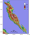
Fichier:Malaita Topography.png

Taille de cet aperçu : 517 × 599 pixels. Autres résolutions : 207 × 240 pixels | 414 × 480 pixels | 662 × 768 pixels | 883 × 1 024 pixels | 1 625 × 1 884 pixels.
Fichier d’origine (1 625 × 1 884 pixels, taille du fichier : 1,33 Mio, type MIME : image/png)
Historique du fichier
Cliquer sur une date et heure pour voir le fichier tel qu'il était à ce moment-là.
| Date et heure | Vignette | Dimensions | Utilisateur | Commentaire | |
|---|---|---|---|---|---|
| actuel | 3 juin 2007 à 12:29 |  | 1 625 × 1 884 (1,33 Mio) | Sadalmelik | {{Information |Description=Topographical map of Malaita Island in Solomon Islands. |Source=Created with GMT from publicly released SRTM data. |Date=June 3, 2007 |Author= User:Sadalmelik }} |
Utilisation du fichier
La page suivante utilise ce fichier :
Usage global du fichier
Les autres wikis suivants utilisent ce fichier :
- Utilisation sur bg.wiki.x.io
- Utilisation sur en.wiki.x.io
- Utilisation sur es.wiki.x.io
- Utilisation sur ja.wiki.x.io
- Utilisation sur ka.wiki.x.io
- Utilisation sur lt.wiki.x.io
- Utilisation sur pt.wiki.x.io
- Utilisation sur ru.wiki.x.io
- Utilisation sur uk.wiki.x.io
- Utilisation sur vi.wiki.x.io
- Utilisation sur zh.wiki.x.io