Fichier:Lage des Landkreises Stendal in Deutschland.PNG
Pas de plus haute résolution disponible.
Lage_des_Landkreises_Stendal_in_Deutschland.PNG (197 × 235 pixels, taille du fichier : 3 kio, type MIME : image/png)
Ce fichier et sa description proviennent de Wikimedia Commons.
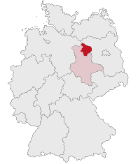
| Description | Landkreis Stendal, Saxony-Anhalt, Germany | ||||||||
| Date | |||||||||
| Source | Travail personnel | ||||||||
| Auteur | own work by Geograv | ||||||||
| Autorisation (Réutilisation de ce fichier) |
|

Historique du fichier
Cliquer sur une date et heure pour voir le fichier tel qu'il était à ce moment-là.
| Date et heure | Vignette | Dimensions | Utilisateur | Commentaire | |
|---|---|---|---|---|---|
| actuel | 1 juillet 2007 à 08:57 | | 197 × 235 (3 kio) | Rauenstein | {{Information |Description=Landkreis Stendal, Saxony-Anhalt, Germany |Source=self |Date=2007-07-01 |Author=own work by Geograv |Permission= {{GFDL}} }} [[Category:Locator maps of districts in Saxony-Anha |
Utilisation du fichier
La page suivante utilise ce fichier :
Usage global du fichier
Les autres wikis suivants utilisent ce fichier :
- Utilisation sur da.wiki.x.io
- Utilisation sur de.wiki.x.io
- Utilisation sur id.wiki.x.io
- Utilisation sur ka.wiki.x.io
- Utilisation sur kk.wiki.x.io
- Utilisation sur pl.wiki.x.io
- Utilisation sur pt.wiki.x.io
- Utilisation sur sv.wiki.x.io