Fichier d’origine (3 200 × 4 000 pixels, taille du fichier : 15,4 Mio, type MIME : image/jpeg)

Ce fichier et sa description proviennent de Wikimedia Commons.

Description

Description
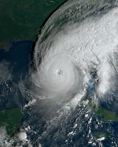
English: This true-color image of Hurricane Ian was recorded on September 28, 2022, at 12:56 UTC (8:56 AM Eastern Daylight Time), utilizing the Advanced Baseline Imager (ABI) instrument aboard NOAA's GOES 16 satellite. Ian, classified as a catastrophic Category 5 hurricane, originated from a developing area east of the Lesser Antilles during the 2022 Atlantic hurricane season, characterized by average but impactful activity. At the time of capture, Hurricane Ian was progressing northeastward, poised for an eventual landfall in the state of Florida later that same day. The storm's devastating impact resulted in a casualty count of at least 161 individuals, with 5 fatalities reported in Cuba, a minimum of 150 in Florida, 5 in North Carolina, and 1 in Virginia. The financial toll incurred by Ian amounted to at least $113 billion in 2022 U.S. dollars, positioning it as the third-costliest tropical cyclone in recorded history. Hurricane Ian, at the time of imaging, was peaking in intensity as a catastrophic Category 5 hurricane, featuring 1-minute sustained winds of 160 mph (260 km/h; 140 kn) according to the Saffir-Simpson scale, coupled with a minimum central pressure of 937 mbar (27.7 inHg).
Date
Source https://realearth.ssec.wisc.edu/
Auteur University of Wisconsin-Madison, Space Science and Engineering Center

Conditions d’utilisation

This image was produced by the SSEC/CIMSS, University of Wisconsin–Madison. All the images published on their website can be freely used, as long as the source is acknowledged. (disclaimer (archive))

© Le détenteur des droits d’auteur de ce fichier autorise n’importe qui à l’utiliser pour n’importe quelle utilisation, pourvu que le détenteur des droits d’auteur soit correctement attribué. La redistribution, les œuvres dérivées, l’utilisation commerciale et toutes les autres utilisations sont autorisées.

Légendes

Ajoutez en une ligne la description de ce que représente ce fichier

Éléments décrits dans ce fichier

dépeint

image/jpeg

Historique du fichier

Cliquer sur une date et heure pour voir le fichier tel qu'il était à ce moment-là.

Date et heureVignetteDimensionsUtilisateurCommentaire
actuel1 février 2023 à 15:51Vignette pour la version du 1 février 2023 à 15:513 200 × 4 000 (15,4 Mio)TheWxResearcherreprojected
15 décembre 2022 à 22:16Vignette pour la version du 15 décembre 2022 à 22:162 600 × 3 400 (10,12 Mio)TheWxResearcher500m resolution
4 octobre 2022 à 14:45Vignette pour la version du 4 octobre 2022 à 14:451 550 × 2 000 (1,29 Mio)Italyoz484M
28 septembre 2022 à 14:29Vignette pour la version du 28 septembre 2022 à 14:291 550 × 2 000 (4,93 Mio)TheWxResearcherUploaded a work by University of Wisconsin-Madison, Space Science and Engineering Center from https://realearth.ssec.wisc.edu/ with UploadWizard

Les 2 pages suivantes utilisent ce fichier :

Usage global du fichier

Métadonnées