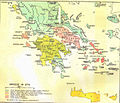
Fichier:Greece in 1278.svg

Taille de cet aperçu PNG pour ce fichier SVG : 800 × 456 pixels. Autres résolutions : 320 × 182 pixels | 640 × 365 pixels | 1 024 × 584 pixels | 1 280 × 730 pixels | 2 560 × 1 460 pixels | 3 508 × 2 000 pixels.
Fichier d’origine (Fichier SVG, nominalement de 3 508 × 2 000 pixels, taille : 1 014 kio)
Historique du fichier
Cliquer sur une date et heure pour voir le fichier tel qu'il était à ce moment-là.
| Date et heure | Vignette | Dimensions | Utilisateur | Commentaire | |
|---|---|---|---|---|---|
| actuel | 23 juin 2017 à 21:04 |  | 3 508 × 2 000 (1 014 kio) | Cplakidas | fixed name |
| 11 avril 2017 à 13:14 |  | 3 508 × 2 000 (1 017 kio) | Cplakidas | colour changes | |
| 8 février 2017 à 19:22 |  | 3 508 × 2 000 (1 018 kio) | Cplakidas | text to paths | |
| 8 février 2017 à 19:11 |  | 3 508 × 2 000 (1 002 kio) | Cplakidas | User created page with UploadWizard |
Utilisation du fichier
Les 4 pages suivantes utilisent ce fichier :
Usage global du fichier
Les autres wikis suivants utilisent ce fichier :
- Utilisation sur ar.wiki.x.io
- Utilisation sur az.wiki.x.io
- Utilisation sur bg.wiki.x.io
- Utilisation sur el.wiki.x.io
- Utilisation sur en.wiki.x.io
- Fourth Crusade
- Principality of Achaea
- Patras
- Battle of Halmyros
- History of Thessaly
- John I Doukas of Thessaly
- Nicholas III of Saint-Omer
- Nicholas II of Saint-Omer
- Matilda of Hainaut
- Boniface of Verona
- Battle of Neopatras
- Battle of Demetrias
- Lordship of Salona
- Jacopo Dondulo
- Byzantine–Venetian treaty of 1277
- Utilisation sur es.wiki.x.io
- Utilisation sur et.wiki.x.io
- Utilisation sur fa.wiki.x.io
- Utilisation sur hr.wiki.x.io
- Utilisation sur hyw.wiki.x.io
- Utilisation sur it.wiki.x.io
- Utilisation sur ja.wiki.x.io
- Utilisation sur ka.wiki.x.io
- Utilisation sur pl.wiki.x.io
- Utilisation sur pt.wiki.x.io
- Utilisation sur ru.wiki.x.io
- Utilisation sur sq.wiki.x.io
- Utilisation sur sr.wiki.x.io
- Utilisation sur tr.wiki.x.io
- Utilisation sur uk.wiki.x.io
- Utilisation sur www.wikidata.org
- Utilisation sur zh.wiki.x.io
Voir davantage sur l’utilisation globale de ce fichier.


