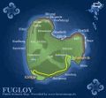
Fichier:FugloyMap.jpg
FugloyMap.jpg (567 × 526 pixels, taille du fichier : 64 kio, type MIME : image/jpeg)
Historique du fichier
Cliquer sur une date et heure pour voir le fichier tel qu'il était à ce moment-là.
| Date et heure | Vignette | Dimensions | Utilisateur | Commentaire | |
|---|---|---|---|---|---|
| actuel | 25 avril 2005 à 08:38 |  | 567 × 526 (64 kio) | Arne List | *Fugloy, the easternmost of the Faroe Islands *Graphic: Anker Eli Petersen *Source: [http://www.faroestamps.fo/?side=f02971c7cc9368c7b145284a8ab80e4e Faroestamps.fo] {{PD}} |
Utilisation du fichier
La page suivante utilise ce fichier :
Usage global du fichier
Les autres wikis suivants utilisent ce fichier :
- Utilisation sur da.wiki.x.io
- Utilisation sur el.wiki.x.io
- Utilisation sur en.wiki.x.io
- Utilisation sur es.wiki.x.io
- Utilisation sur hu.wiki.x.io
- Utilisation sur is.wiki.x.io
- Utilisation sur it.wiki.x.io
- Utilisation sur nl.wiki.x.io
- Utilisation sur pl.wiki.x.io
- Utilisation sur pt.wiki.x.io
- Utilisation sur ro.wiki.x.io
- Utilisation sur ru.wiki.x.io
- Utilisation sur sv.wiki.x.io
- Utilisation sur vi.wiki.x.io
- Utilisation sur zh.wiki.x.io
