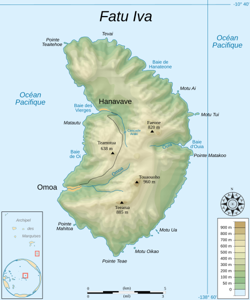
Fichier:FatuIva topographic map-fr.svg

Taille de cet aperçu PNG pour ce fichier SVG : 500 × 600 pixels. Autres résolutions : 200 × 240 pixels | 400 × 480 pixels | 640 × 768 pixels | 853 × 1 024 pixels | 1 707 × 2 048 pixels | 750 × 900 pixels.
Fichier d’origine (Fichier SVG, nominalement de 750 × 900 pixels, taille : 414 kio)
Historique du fichier
Cliquer sur une date et heure pour voir le fichier tel qu'il était à ce moment-là.
| Date et heure | Vignette | Dimensions | Utilisateur | Commentaire | |
|---|---|---|---|---|---|
| actuel | 19 août 2007 à 11:04 |  | 750 × 900 (414 kio) | Sémhur | + road |
| 8 août 2007 à 14:53 |  | 750 × 900 (171 kio) | Sémhur | + shaded relief | |
| 8 août 2007 à 13:27 |  | 750 × 900 (168 kio) | Sémhur | == Description == {{en}} {{Information| |Description=Topographic map in French of the island of Fatu Hiva, Marquesas Islands, French Polynesia. |Source=Own work.{{clr}} Datas : * Background map : [http://www2.jpl.nasa.gov/srtm NASA Shutt |
Utilisation du fichier
Les 2 pages suivantes utilisent ce fichier :
Usage global du fichier
Les autres wikis suivants utilisent ce fichier :
- Utilisation sur ca.wiki.x.io
- Utilisation sur de.wiki.x.io
- Utilisation sur en.wiki.x.io
- Utilisation sur eo.wiki.x.io
- Utilisation sur es.wiki.x.io
- Utilisation sur fa.wiki.x.io
- Utilisation sur fi.wiki.x.io
- Utilisation sur gl.wiki.x.io
- Utilisation sur he.wiki.x.io
- Utilisation sur no.wiki.x.io
- Utilisation sur pl.wiki.x.io