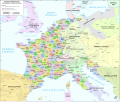
Fichier:Map administrative divisions of the First French Empire 1812-en.svg

Taille de cet aperçu PNG pour ce fichier SVG : 712 × 600 pixels. Autres résolutions : 285 × 240 pixels | 570 × 480 pixels | 912 × 768 pixels | 1 216 × 1 024 pixels | 2 432 × 2 048 pixels | 2 052 × 1 728 pixels.
Fichier d’origine (Fichier SVG, nominalement de 2 052 × 1 728 pixels, taille : 4,14 Mio)
Historique du fichier
Cliquer sur une date et heure pour voir le fichier tel qu'il était à ce moment-là.
| Date et heure | Vignette | Dimensions | Utilisateur | Commentaire | |
|---|---|---|---|---|---|
| actuel | 16 juin 2024 à 17:55 |  | 2 052 × 1 728 (4,14 Mio) | 밥풀떼기 | File uploaded using svgtranslate tool (https://svgtranslate.toolforge.org/). Added translation for ko. |
| 9 février 2024 à 13:33 |  | 2 052 × 1 728 (3,86 Mio) | Manlleus | added catalan language | |
| 21 mai 2021 à 18:10 |  | 2 052 × 1 728 (3,55 Mio) | Andrei Stroe | File uploaded using svgtranslate tool (https://svgtranslate.toolforge.org/). Added translation for ro. | |
| 30 août 2020 à 13:32 |  | 2 052 × 1 728 (3,24 Mio) | Jfblanc | File uploaded using svgtranslate tool (https://svgtranslate.toolforge.org/). Added translation for oc. | |
| 1 mars 2018 à 11:37 |  | 2 052 × 1 728 (2,83 Mio) | Imperator Honorius | Formatting Fix | |
| 1 mars 2018 à 11:29 |  | 2 052 × 1 728 (2,83 Mio) | Imperator Honorius | Formatting and missing Anglicization (Gand to Ghent) | |
| 1 mars 2018 à 11:17 |  | 2 052 × 1 728 (2,83 Mio) | Imperator Honorius | Spelling and typos; more Anglicised (and up to date) city names. | |
| 20 juillet 2015 à 20:41 |  | 2 052 × 1 728 (2,82 Mio) | ArdadN | spelling | |
| 20 juillet 2015 à 18:11 |  | 2 052 × 1 728 (2,81 Mio) | ArdadN | 1 | |
| 20 juillet 2015 à 18:05 |  | 2 052 × 1 728 (2,81 Mio) | ArdadN | font size |
Utilisation du fichier
Les 5 pages suivantes utilisent ce fichier :
Usage global du fichier
Les autres wikis suivants utilisent ce fichier :
- Utilisation sur af.wiki.x.io
- Utilisation sur ar.wiki.x.io
- Utilisation sur ca.wiki.x.io
- Utilisation sur en.wiki.x.io
- History of the Netherlands
- 1810s
- Departments of France
- 130 departments of the First French Empire
- Illyrian Provinces
- Kingdom of Italy (Napoleonic)
- Portal:Maps/Maps/Political
- Portal:Maps/Maps/Political/14
- First French Empire
- Bouches-del'Èbre
- Department of Segre
- Left Bank of the Rhine
- User:Dakaysaa/sandbox
- User:Falcaorib/France
- Utilisation sur et.wiki.x.io
- Utilisation sur hr.wiki.x.io
- Utilisation sur it.wiki.x.io
- Utilisation sur ka.wiki.x.io
- Utilisation sur km.wiki.x.io
- Utilisation sur krc.wiki.x.io
- Utilisation sur mt.wiki.x.io
- Utilisation sur no.wiki.x.io
- Utilisation sur pl.wiki.x.io
- Utilisation sur pnb.wiki.x.io
- Utilisation sur pt.wiki.x.io
- Utilisation sur ru.wiki.x.io
- Utilisation sur tr.wiki.x.io
- Utilisation sur ur.wiki.x.io
- Utilisation sur vi.wiki.x.io


