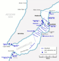
Fichier:Dardanelles defences 1915.png

Taille de cet aperçu : 580 × 599 pixels. Autres résolutions : 232 × 240 pixels | 600 × 620 pixels.
Fichier d’origine (600 × 620 pixels, taille du fichier : 137 kio, type MIME : image/png)
Historique du fichier
Cliquer sur une date et heure pour voir le fichier tel qu'il était à ce moment-là.
| Date et heure | Vignette | Dimensions | Utilisateur | Commentaire | |
|---|---|---|---|---|---|
| actuel | 21 juin 2012 à 19:02 |  | 600 × 620 (137 kio) | Hohum | Clearer colours |
| 22 juin 2005 à 17:51 |  | 600 × 620 (74 kio) | Redtony | Map of the Dardanelles defences in February and March, 1915. The original lines of naval mines are numbered 1 to 10. The 11th line, laid in Erin Keui Bay by the minelayer ''Nusrat'' on 8 March, is numbered 11. The anti-submarine nets are shown as d |
Utilisation du fichier
Les 3 pages suivantes utilisent ce fichier :
Usage global du fichier
Les autres wikis suivants utilisent ce fichier :
- Utilisation sur ast.wiki.x.io
- Utilisation sur be-tarask.wiki.x.io
- Utilisation sur be.wiki.x.io
- Utilisation sur bg.wiki.x.io
- Utilisation sur ca.wiki.x.io
- Utilisation sur de.wiki.x.io
- Utilisation sur en.wiki.x.io
- HMS Ocean (1898)
- HMS Goliath (1898)
- HMS Irresistible (1898)
- Naval operations in the Dardanelles campaign
- HMS Albion (1898)
- Lord Nelson-class battleship
- Eric Gascoigne Robinson
- French battleship Suffren
- HMS Cornwallis (1901)
- SMS Kurfürst Friedrich Wilhelm
- SMS Weissenburg
- HMS Agamemnon (1906)
- Charlemagne-class battleship
- French battleship Gaulois
- French battleship Charlemagne
- HMS Vengeance (1899)
- Dardanelles Fortified Area Command
- Gulf of Erenköy
- Ottoman minelayer Intibah
- Utilisation sur es.wiki.x.io
- Utilisation sur he.wiki.x.io
- Utilisation sur it.wiki.x.io
- Utilisation sur ja.wiki.x.io
- Utilisation sur ka.wiki.x.io
- Utilisation sur pl.wiki.x.io
- Utilisation sur pt.wiki.x.io
Voir davantage sur l’utilisation globale de ce fichier.
