Fichier:Amurrivermap.png

Taille de cet aperçu : 761 × 599 pixels. Autres résolutions : 305 × 240 pixels | 610 × 480 pixels | 989 × 779 pixels.
Fichier d’origine (989 × 779 pixels, taille du fichier : 298 kio, type MIME : image/png)
Ce fichier et sa description proviennent de Wikimedia Commons.
| Description |
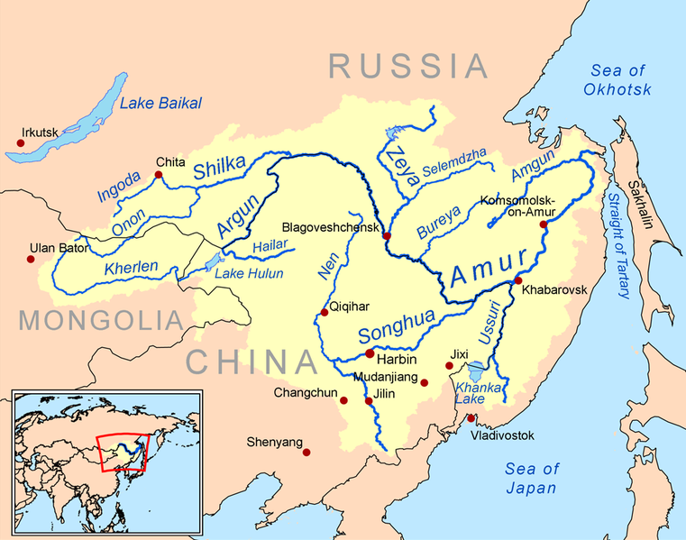
English: This is a map of the Amur River drainage basin. Русский: Карта бассейна реки Амур. |
| Date | |
| Source | Own work using Digital Chart of the World and GTOPO data. |
| Auteur | Kmusser |
| Autres versions |
Œuvres dérivées de ce fichier : Amurriversourcesmap.jpg File:Amur watershed.png |
Moi, en tant que détenteur des droits d’auteur sur cette œuvre, je la publie sous la licence suivante :
Ce fichier est disponible selon les termes de la licence Creative Commons Attribution – Partage dans les Mêmes Conditions 3.0 (non transposée).
- Vous êtes libre :
- de partager – de copier, distribuer et transmettre cette œuvre
- d’adapter – de modifier cette œuvre
- Sous les conditions suivantes :
- paternité – Vous devez donner les informations appropriées concernant l'auteur, fournir un lien vers la licence et indiquer si des modifications ont été faites. Vous pouvez faire cela par tout moyen raisonnable, mais en aucune façon suggérant que l’auteur vous soutient ou approuve l’utilisation que vous en faites.
- partage à l’identique – Si vous modifiez, transformez, ou vous basez sur cette œuvre, vous devez distribuer votre contribution sous la même licence ou une licence compatible avec celle de l’original.

|
Cette image (de type carte) devrait être recréée dans un format vectoriel, en tant que fichier SVG. Cela offrirait plusieurs avantages : voir Commons:Media for cleanup pour plus d'informations. Si une version SVG de cette image est déjà disponible, merci de bien vouloir l'envoyer. Après cela, remplacez ce modèle par {{vector version available|nouveau nom d'image.svg}}.
|
Historique du fichier
Cliquer sur une date et heure pour voir le fichier tel qu'il était à ce moment-là.
| Date et heure | Vignette | Dimensions | Utilisateur | Commentaire | |
|---|---|---|---|---|---|
| actuel | 7 juin 2010 à 03:15 | | 989 × 779 (298 kio) | Ras67 | cropped |
| 2 mars 2009 à 22:05 |  | 1 000 × 795 (367 kio) | Kmusser | {{Information |Description=This is a map of the Amur River drainage basin. |Source=Own work using [http://www.maproom.psu.edu/dcw/ Digital Chart of the World] and [http://edc.usgs.gov/products/elevation/gtopo30/gtopo30.html GTOPO] data. |
Utilisation du fichier
Les 4 pages suivantes utilisent ce fichier :
Usage global du fichier
Les autres wikis suivants utilisent ce fichier :
- Utilisation sur af.wiki.x.io
- Utilisation sur als.wiki.x.io
- Utilisation sur ar.wiki.x.io
- Utilisation sur ast.wiki.x.io
- Utilisation sur azb.wiki.x.io
- Utilisation sur be-tarask.wiki.x.io
- Utilisation sur bg.wiki.x.io
- Utilisation sur bh.wiki.x.io
- Utilisation sur bn.wiki.x.io
- Utilisation sur br.wiki.x.io
- Utilisation sur bs.wiki.x.io
- Utilisation sur ca.wiki.x.io
- Utilisation sur crh.wiki.x.io
- Utilisation sur cy.wiki.x.io
- Utilisation sur da.wiki.x.io
- Utilisation sur de.wiki.x.io
- Utilisation sur en.wiki.x.io
- Utilisation sur eo.wiki.x.io
- Utilisation sur es.wiki.x.io
Voir davantage sur l’utilisation globale de ce fichier.