Fichier:AMH-5475-NA Map of the fort of Grissé and environs.jpg

Taille de cet aperçu : 742 × 599 pixels. Autres résolutions : 297 × 240 pixels | 594 × 480 pixels | 951 × 768 pixels | 1 268 × 1 024 pixels | 2 400 × 1 939 pixels.
Fichier d’origine (2 400 × 1 939 pixels, taille du fichier : 628 kio, type MIME : image/jpeg)
Ce fichier et sa description proviennent de Wikimedia Commons.
Description
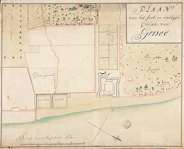
Nederlands: Kaart van het fort van Grissé en omgeving
English: Map of the fort of Grissé and environs( |
||||||||||||||||||||||||
|---|---|---|---|---|---|---|---|---|---|---|---|---|---|---|---|---|---|---|---|---|---|---|---|---|
| Auteur |
Nederlands: Anoniem / Anonymous (landmeter / kaartenmaker)
English: Anoniem / Anonymous (land surveyor / mapmaker) |
|||||||||||||||||||||||
| Titre |
Nederlands: Kaart van het fort van Grissé en omgeving
English: Map of the fort of Grissé and environs |
|||||||||||||||||||||||
| Description |
Nederlands: Titel catalogus Leupe (NA): Plaan van het Fort en omleggende cituatie van Griseé.
Notities verso: Plaan van het Fort en omleggende cituatie van Grissee anno 1719 [twee keer] / No. 21 Plan en omliggende situatie van Grissé. Register 2, Deel 1, Folio 7, Portefeuille .. [geschreven op een blauw etiket] / 641 [met vette cijfers gestempeld op een etiketje] / No. 78. [vrij groot, op een etiket] / no. 195.
English: Title in the Leupe catalogue (NA):Plaan van het Fort en omleggende cituatie van Griseé.
Notes on reverse: Plaan van het Fort en omleggende cituatie van Grissee anno 1719 [twice] / No. 21 Plan en omliggende situatie van Grissé. Register 2, Deel 1, Folio 7, Portefeuille .. [inscribed on a blue label] / 641 [stamped in bold on a small label] / No. 78. [reasonably large, on a label] / no. 195.
Bahasa Indonesia: Judul dalam katalog Leupe (AN):Plaan van het Fort en omleggende cituatie van Griseé.
Catatan di belakang: Plaan van het Fort en omleggende cituatie van Grissee anno 1719 [dua kali] / No. 21 Plan en omliggende situatie van Grissé. Register 2, Deel 1, Folio 7, Portefeuille .. [ditulis dalam label biru] / 641 [dicetak tebal dalam label kecil] / No. 78. [berukuran besar, dalam sebuah label] / no. 195. |
|||||||||||||||||||||||
| Date | vers 1719 | |||||||||||||||||||||||
| Technique / matériaux |
Nederlands: ingekleurde tekening op papier
English: coloured drawing on paper
Bahasa Indonesia: gambar berwarna di atas kertas |
|||||||||||||||||||||||
| Dimensions | hauteur : 51 cm ; largeur : 41,5 cm | |||||||||||||||||||||||
| Collection |
|
|||||||||||||||||||||||
| Numéro d’inventaire |
NL-HaNA_4.VEL_1277 (old number: VEL1277) |
|||||||||||||||||||||||
| Inscriptions |
Plaan van het Fort en omleggende cituatie van Griseé
|
|||||||||||||||||||||||
| Notes |
English: Subjects: chart / map / plan, fortification, estate / plantation
Nederlands: Onderwerpen: plattegrond / kaart, vesting, landerij / plantage
English: Post: this image is related to a VOC trading post called Gresik |
|||||||||||||||||||||||
| Source / photographe |
|
|||||||||||||||||||||||
| Autorisation (Réutilisation de ce fichier) |
|
|||||||||||||||||||||||

| Position de l'objet | | Voir cet endroit et d’autres images sur : OpenStreetMap |
|---|
Historique du fichier
Cliquer sur une date et heure pour voir le fichier tel qu'il était à ce moment-là.
| Date et heure | Vignette | Dimensions | Utilisateur | Commentaire | |
|---|---|---|---|---|---|
| actuel | 10 juin 2014 à 20:27 | | 2 400 × 1 939 (628 kio) | HuskyBot | == {{int:filedesc}} == {{Artwork |title = {{nl|1=Kaart van het fort van Grissé en omgeving}} {{en|1=Map of the fort of Grissé and environs}} |description = {{nl|1=Titel catalogus Leupe (NA): ''Plaan van het F... |
Utilisation du fichier
La page suivante utilise ce fichier :