Fichier:1846 Burroughs - Mitchell Map of Argentina, Uruguay, Chili in South America - Geographicus - LaPlata-m-1946.jpg

Taille de cet aperçu : 495 × 599 pixels. Autres résolutions : 198 × 240 pixels | 396 × 480 pixels | 634 × 768 pixels | 846 × 1 024 pixels | 1 692 × 2 048 pixels | 2 891 × 3 500 pixels.
Fichier d’origine (2 891 × 3 500 pixels, taille du fichier : 2,95 Mio, type MIME : image/jpeg)
Ce fichier et sa description proviennent de Wikimedia Commons.
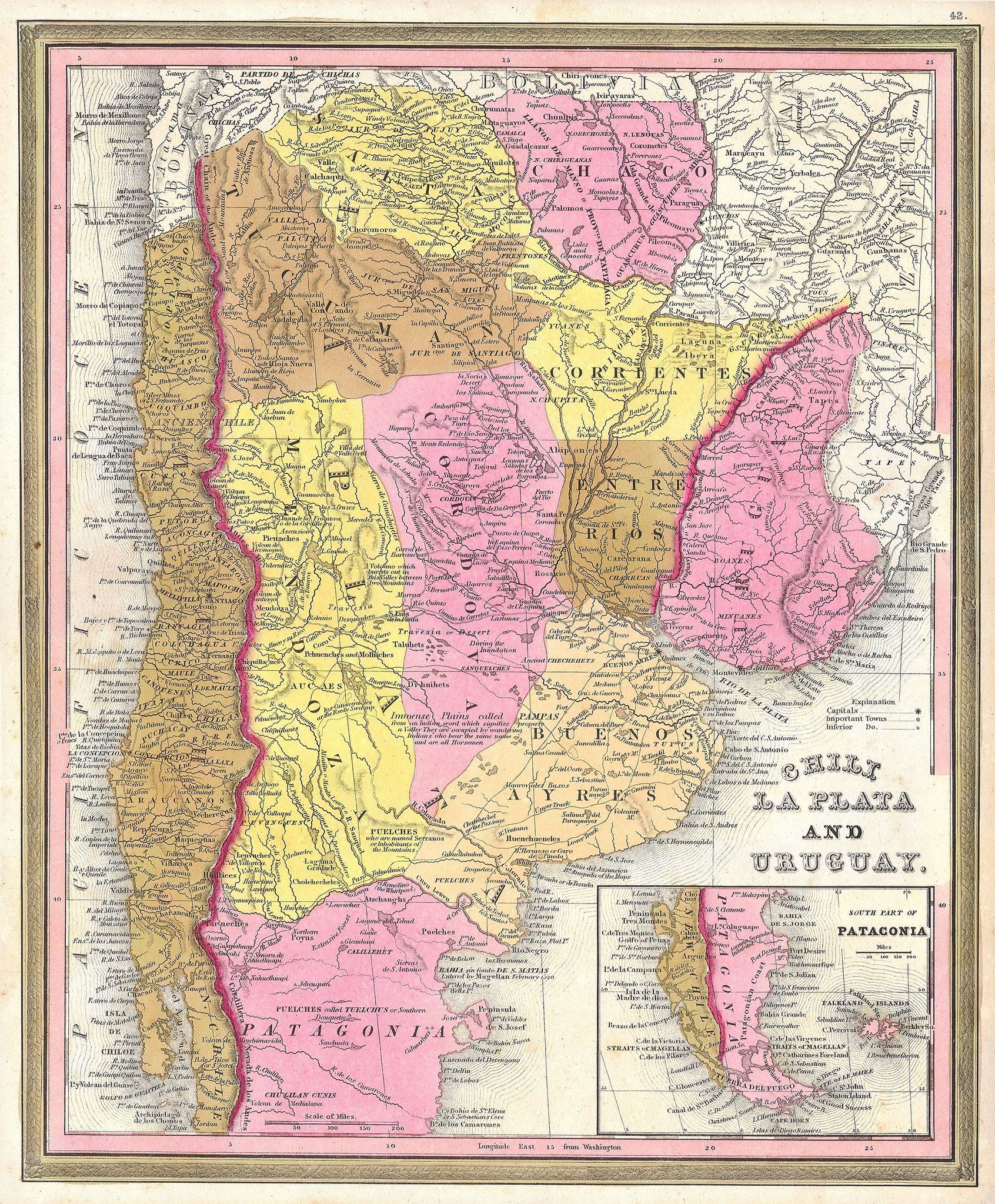
| Samuel Augustus Mitchell : Chili La Plata and Uruguay. South Part of Patagonia.
( |
||||||||||||||||||||
|---|---|---|---|---|---|---|---|---|---|---|---|---|---|---|---|---|---|---|---|---|
| Artiste |
|
|||||||||||||||||||
| Titre |
Chili La Plata and Uruguay. South Part of Patagonia. |
|||||||||||||||||||
| Description |
English: This scarce hand colored map is a lithographic engraving of Chili, La Plata and Uruguay, dating to 1846 by the legendary American Mapmaker S.A. Mitchell, the elder. Mostly depicts modern day Argentina. There is an inset of Patagonia and Tierra del Fuego on the bottom right. There is no engraver listed, but this is most likely a Burroughs map. H. N. Burroughs is a mysterious transitional engraver, whose work for the Mitchell firm appears in 1846 between that of H.S. Tanner and Mitchell himself. Ristow notes, Nothing is known about Burroughs, but he was undoubtedly an employee or associate of Mitchell. His fine and detailed work appears only in certain hard to find mid 1840s editions of the Mitchell’s Atlas. |
|||||||||||||||||||
| Date | 1846 | |||||||||||||||||||
| Dimensions | hauteur : 12,5 pouces (31,7 cm) ; largeur : 15 pouces (38,1 cm) | |||||||||||||||||||
| Numéro d’inventaire |
liens Geographicus : LaPlata-m-1946 |
|||||||||||||||||||
| Source / photographe |
|
|||||||||||||||||||
| Autorisation (Réutilisation de ce fichier) |
|
|||||||||||||||||||
Historique du fichier
Cliquer sur une date et heure pour voir le fichier tel qu'il était à ce moment-là.
| Date et heure | Vignette | Dimensions | Utilisateur | Commentaire | |
|---|---|---|---|---|---|
| actuel | 12 mars 2011 à 14:39 | | 2 891 × 3 500 (2,95 Mio) | BotMultichill | {{subst:User:Multichill/Geographicus |link=http://www.geographicus.com/P/AntiqueMap/LaPlata-m-1946 |product_name=1846 Burroughs - Mitchell Map of Argentina, Uruguay, Chili in South America |map_title=Chili La Plata and Uruguay. South Part of Patagonia. |
Utilisation du fichier
La page suivante utilise ce fichier :
Usage global du fichier
Les autres wikis suivants utilisent ce fichier :
- Utilisation sur ca.wiki.x.io
- Utilisation sur es.wiki.x.io
- Utilisation sur nl.wiki.x.io
- Utilisation sur sk.wiki.x.io
- Utilisation sur zh.wiki.x.io